Terrestrial LiDar services
Definition Terrestrial LiDar

Terrestrial Lidar definition

Lidar is a measurement instrument which uses a light bundle to collect dense, georeferenced XYZ point clouds which will be used to represent an object or the morphology of a site in 3D. In terrestrial topography, using lasergrammetry is adapted to surveys with different accuracy levels (from a few millimeters to a few centimeters). Different terrestrial lidar systems can be static or dynamic (embedded on a moving vehicle or hand-held).

3D laser scanner surveys and other terrestrial LiDAR services

In 2001, our chartered surveying company was the first in France to be equipped with a terrestrial 3D laser scanner (lidar) and was a genuine pioneer in lasergrammetry. Since, we have kept pace with all the latest evolutions in equipment and software dedicated to acquisition and point cloud processing. Over the course of 16 years experience in terrestrial lidar services, we have enriched and developed our expertise.

We have several types of scanners adapted to all types of surveys, depending on deadline, accuracy and mobility requirements. We have the resources to deploy several teams at once in the field, which makes us especially competitive in terms of fast turnaround times and tight deadlines.

The 3D laser scanning measurement technique enables acquisition of comprehensive, dense, accurate XYZ point clouds, which can be georeferenced in any local or absolute reference system.

With our expertise in post-processing software, we produce high quality 2D and 3D services and deliverables in different fields:

  • Heritage sites and architecture
  • Industrial and scientific sectors
  • Civil engineering and Building and Public works,
  • Digital models and 3D modeling…

Photogrammetry techniques are used to enrich 3D models produced from lasergrammetry (such as building walls) using texturing and coloring techniques to give high resolution photorealistic rendering.

Our expertise in aerial, underground and bathymetric surveys completes our terrestrial lidar surveys, to produce 2D, 3D or 4D comprehensive topographic documents.

Terrestrial LiDAR applications

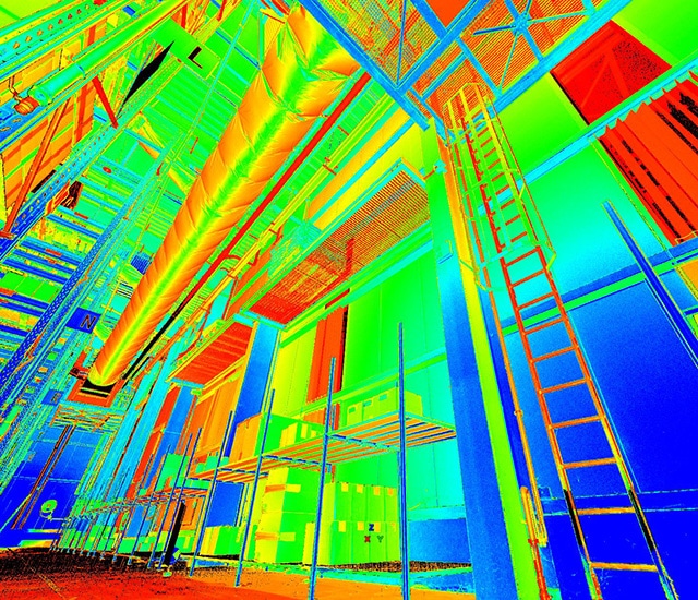
Terrestrial LiDAR is used for 3D surveys of buildings, structures, objects and complex scenes for which traditional topometry and photogrammetry are not suitable. This contactless measurement technology which uses laser light as a data support, does away with the need to access dangerous zones, as well as allowing very fast, autonomous, high density inputs. The comprehensive information acquired means that there is no need to return to the field for complementary information.

It is possible to deliver different products to answer a wide range of requirements, using accurate, dense point clouds acquired with this technique.

Lasergrammetry is often combined with classical terrestrial or photogrammetric surveys.

As-built or as-scanned models delivered can be very attractive and extremely comprehensive.

Applications include:

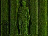
  • The field of architecture, cultural heritage sites and archeology:
    • Site conservation and management,
    • Indoor plans, walls and cross-sections,
    • Framework or roofing plans,
    • Layout and equipment,
    • 3D models and BIM files (IFC), with photorealistic rendering.
  • Industrial and scientific fields:
    • Revamping and prototyping on production sites,
    • Valve chamber and production facilities,
    • Engine rooms,
    • Scientific equipment and facilities,
    • Complex or large sized mechanical parts…
  • Civil engineering:
    • 3D modeling of tunnels, viaducts, bridges,
    • Roadwork and highway surveys,
    • Confined spaces, galeries,
    • Penstock pipe, water intake structures, dam,
    • Dikes…
  • Digitalization for digital models:
    • 3D modeling of complex objects,
    • Urban furniture,
    • Built environment, structures and equipment…

Equipment

Thanks to its extensive resources, the company can deploy several teams in the field at once while being totally independent. Using terrestrial lidar ensures the safety of teams while protecting them from exposure to dangerous situations during the physical survey (rough terrain, highways, etc.)

In terms of terrestrial lidar equipment, we have several types of laser scanners that we use depending on their specific performances and the service required:

  • Long-range scanner,
  • Short-range high resolution scanner,
  • Hand-held mobile scanner.

To deliver surveys with large lines or surfaces, we can organize mobile mapping solutions.

references

Palace of Versailles – Royal Chapel

Hauts de Seine (France)


3D modeling of the entire framework of the chapel (1 700 parts) depending on the structure theme – Vector map of walls at 1/50.

ALTEA – Hôtel Dieu Lyon

Rhône (France)


Wall plans at 1/200 – Indoor plans at 1/100 for a cultural heritage site restoration survey.

EDF CIH – Chastang dam

Corrèze (France)


Comprehensive 3D modeling of the exterior part of the dam – Top view and cross sections for a behavioral study of the structure.

Fondation Pinault – Old Stock exchange

Paris (France)


3D modeling of notable equipment for digital archiving within the framework of industrial cultural heritage sites.