Orthophotography services
Definition Orthophotomap

Orthophotomap definition

An orthophotomap is an aerial photographic image in which distortions related to the elevation and perspective have been removed by differential rectification. An orthophotomap is thus a metric document which can be perfectly overlapped with a vector map.

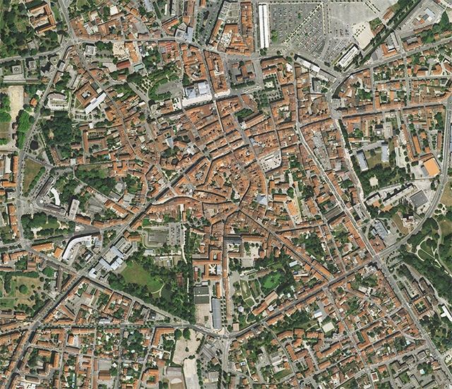
Orthophotography and Orthoimagery services (GIS)

Our company is equipped to produce orthophotography services on large areas while keeping costs down and delivering fast turnaround times thanks to an efficient, proven production chain and in-depth study of flight plans to optimize acquisition times and the number of images.

A pioneer in France in the field of photogrammetry and orthophotomap production, Sintégra has been providing its expertise and state-of-the-art equipment to customers all over the world (Europe, Africa, Asia…). We produce aerial photographs using the most appropriate aircraft (plane, helicopter, or drone), depending on the geographic location of sites, morphology and resolution needed. Consequently, we are equipped to deliver orthophotography and orthoimagery services on the scale of an entire county or a work of art.

Orthophotography applications

An orthophotomap is often integrated in the GIS in a standard format (GeoTIFF, ECW/ERS…) as it is especially of interest to visualize the use and nature of a surface. And as it has often been said that a picture is worth a thousand words, orthophotomaps are also often used for communication purposes.

We tailor our orthophotography services to all types of requirements:

  • A comprehensive overview of a territory:
    • Creation of topographical representation systems:
      • GIS (Geographic Information Systems),
      • Creation of models…
    • Infrastructure study:
      • Road, rail and waterway development and planning,
      • Energy transportation,
      • Installation of fiber optic cables and power lines,
      • Pipelines…
    • Natural hazards:
      • Flood risk mapping,
      • Gravitational hazards, erosion…
    • Hydrography and dams:
      • Hydrographic maps,
      • Impact studies, environmental studies,
      • Rising water level simulations…
    • Status archiving:
      • After a major event (natural catastrophe),
      • To preserve a legal record to be effective against a former status.
    • Forestry and agriculture:
      • Forestry inventory,
      • Health assessment (infra red)…
    • Texturing tool (« mapping ») and 3D model coloring.

Technical resources and equipment

Orthophotomaps are produced thanks to aerial photographs taken with digital cameras embedded on any aerial survey aircraft:

  • Large format cameras (Z/I DMC and DMCII)
  • Medium format cameras (Leica RCD30, Hasselblad and Phase One)
  • Single engine (Cessna 206TU) or twin engine (Beechcraft 200, Beechcraft 90, Partenavia P68C) aircrafts
  • Helicopters
  • Rotary wing UAVs (Terradrone, DJI) or fixed wing UAVs (eBee)

The cameras used take pictures in color (RGB) or in near infrared (NIR). Thanks to our equipment, we are flexible and can deliver optimal customer solutions with fast turnaround times.

références

E-megalis

Morbihan (France)


Orthophotoplan à 20 cm de tout le département sur 8 239 km² pour gestion du territoire et intégration au SIG.

Grand Lyon

Rhône (France)


Orthophotoplan à 5 cm sur 1400 km² pour mise à jour du SIG.

Bordeaux Métropole

Gironde (France)


Orthophotoplan à 10 cm sur 620 km² pour gestion du territoire et intégration au SIG.

High River Gold

La Volta Blanche (Burkina Faso)


Orthophotoplan à 20 cm sur 5 145 km² pour exploration minière et gestion des ressources.