
Bathymetry

We carry out custom bathymetric surveys, either stand-alone or as part of projects combining bathymetry with aerial or terrestrial topography. By synchronizing these data, we create continuous models of submerged and emergent areas, using technologies such as airborne bathymetric lidar and echo sounders, in environments such as lakes, rivers and streams.

These surveys are crucial for hydraulic planning, river management and flood protection. We provide customized deliverables, such as plans with isobath curves, point clouds, profiles and cubatures.

Deux hommes en veste orange effectuent une mesure bathymétrique dune rivière. Lun se tient sur la rive et tient un équipement, tandis que lautre est dans leau avec une perche de mesure. Un radeau se trouve au premier plan et une petite cascade tombe doucement en arrière-plan.

Our services

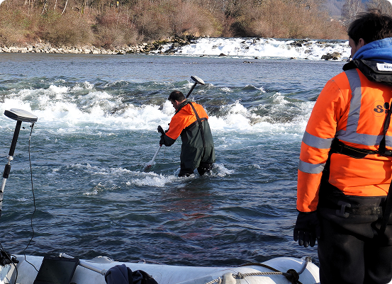
Depending on the type of watercourse, we use a range of bathymetry techniques, from a simple pigeon to a single-beam or multibeam echo sounder, synchronized by GPS or total station, and embarked on a boat or drone.

These varied methods guarantee maximum precision, ensuring the highest quality readings.

  • Techniques adapted to the type of watercourse: Selection of the most appropriate methods according to the characteristics of the watercourse (width, depth, current, etc.).
  • Pigeon-hole, single-beam or multibeam echo sounder: Choice of the most suitable instrumentation for bathymetric measurements, depending on project requirements.
  • Data synchronization via GPS or total station: Precise integration of geospatial data thanks to advanced positioning tools.
  • Equipment mounted on boats or drones: mobile platforms for flexible aerial or waterborne surveys.

Our strengths

SINTEGRA has extensive experience in bathymetric surveys, particularly of lakes, rivers and seas. We use advanced technologies such as single-beam, multibeam echo sounders and airborne bathymetric lidar, adapted to each environment. This expertise enables us to produce accurate, reliable models that meet the specific requirements of each project.

Transport networks & infrastructure
Energy & distribution networks
Environmental studies & risks
Architecture & heritage
Industry
Regional planning

Our expertise

Every day, our teams use cutting-edge technologies to revolutionize cartography.

Our expertise

Do you have a question?