As-built 3D laser scanning
Definition 3D model

3D model definition

A 3D model is a digital representation of the geometry of an object in three dimensions. It is used for many purposes: dimensional checks, digital archiving, visualization, prototyping, interactive virtual models. To produce a 3D model you need an accurate, comprehensive three dimensional survey of the object geometry which can be done using capture techniques such as photogrammetry or laser scanning.

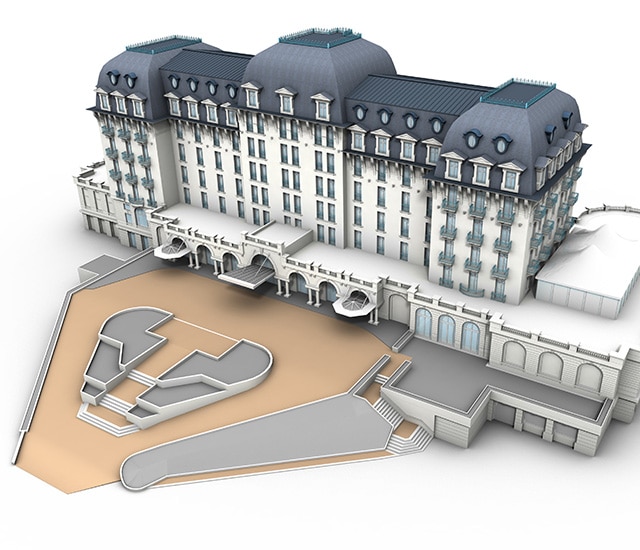
As-built 3D surveys by laser scanning or photogrammetry, as-built BIM models

Our as-built 3D modeling department uses Sintégra’s multi-disciplinary expertise in data acquisition:

Sintégra uses planes, helicopters and drones to perform aerial surveys depending on the desired resolution and configuration of the sites to be scanned or photographed.

We are equipped to implement fixed (eBee) or rotary wing (DJI) UAVs.

This equipment is used to make ultra-accurate captures and are efficient for both hard to reach zones and surveys over a moving object.

Since 1961, Sintégra has been a pioneer in France in 3D modeling, first thanks to 3D photogrammetry and then since 2000 using laser scanning. Thanks to our extensive experience, we have in-depth knowledge of the evolution of the technology and we use state-of-the art 3D modeling techniques and tools.

For any service, our teams of engineers, technicians and graphic artists go beyond simply using existing tools. Thanks to our dynamic R&D department, we engage in extensive technological watch and we develop our own systems tailored to specific demands. Hence, the company is capable of meeting new requirements and answering very complex project needs.

Our models comply with very strict geometric specifications and they can be exported to different existing visualization or analysis software in most standard formats used in CAD.

3D modeling applications

As-built 3D laser scanning produces models that are commonly used in reverse engineering and revamping. The CAD model produced is used to optimize a manufacturing process, repair or produce new parts or identical objects by prototyping, or carry out dimensional checks.

It can also serve as a digital archive, or a record of an industrial or architectural heritage site.


There are many applications:

  • Industrial application or as-built equipment:
    • Valve chamber,
    • Petrochemical complex,
    • Waste disposal center…
  • Heritage sites and archeology:
    • Virtual tour,
    • Simulation,
    • Mapping results/current situation,
    • Framework plan,
    • Interior plan.
  • Civil engineering modeling, structural engineering and hydrology:
    • Dam, embankment,
    • Tunnel,
    • Bridge or viaduct,
    • Roads, streets,
    • Confined areas, gallery,
    • Penstock…

Technical resources

To capture the geometry of objects to be modeled, Sintégra uses different airborne or terrestrial surveying equipment including:

  • Aircrafts used for our aerial acquisitions:
    • Single engine (Cessan 206TU) and twin engine (Beechcraft Baron 200 and Partenavia P68C) transcontinental planes,
    • Helicopters,
    • Rotary wing (Terradrone, DJI) or fixed wing (eBee) drones.
  • Photogrammetric cameras:
    • Large format (Z/I DMC and DMCII),
    • Middle format (Leica RCD30, Hasselblad and Phase One).
  • Static or mobile laser scanners:
    • Leica (P20, HDS6200), and dynamic Pegasus 2,
    • Faro (Focus X330),
    • Dynamic Geoslam.


Our models are the product of point cloud processing and stereoscopic image pairs using specialized software:

  • Airborne Lidar: Terrasolid
  • Terrestrial Lidar: Cyclone, RealWorks, AutoPP, MapFactory, TerraSolid
  • Photogrammetry: LPS/Microstation Pro600


We also use other computer graphics tools for more advanced processing specific to computer generated images or 3D digitalization such as:

  • 3DS Max, Maya
  • Rhino

références

Fondation Pinault – Ancienne bourse du commerce

Paris (France)


Modélisation 3D haute résolution d’équipements techniques anciens à partir de données lasergrammétriques pour archivage numérique destiné à la mise en valeur.

Établissement Public du Château de Versailles – Chapelle Royale

Les Yvelines (France)


Modélisation 3D complète de la charpente (plus de 1 700 éléments) à partir de données lasergrammétriques pour étude de charpente (rénovation et entretien).


EDF CIH – Barrage de Chastang

Corrèze (France)


Levé lasergrammétrique et photographique – Modélisation 3D filaire précise de la géométrie de l’ouvrage – Maquette virtuelle texturée pour étude de réhabilitation.

Ville de Nice – Service Archéologie – Site romain de Cimiez

Alpes Maritimes (France)


Levé lasergrammétrique et photographique complet du site – Modélisation 3D filaire texturée de tous les murs et anciens ouvrages pour étude archéologique et archivage numérique.