Underground Utility Survey
Definition Underground utility surveys

Underground utility surveys definition

Underground utility mapping is a technique used to detect and georeference underground structures including water pipelines, telecommunication cables, gas pipelines, etc. For a construction project, underground utility surveys can be used to produce georeferenced as-built plans, which in turn are used to establish a comprehensive assessment of below ground space usage.

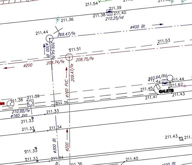
Underground Utility Survey & Mapping

Our chartered surveying company delivers underground utility surveys on a regular basis for georeferenced as-built plans within the framework of application of the French law “DT-DICT” on damage prevention of sensitive utilities and pipelines, for which the position of underground utilities must be accurately identified.

If you need more reliable, more comprehensive underground utility surveys, we can go further than a simple survey of near surface features, thanks to our specialized tools for detecting difficult to locate underground utilities.

When open cut surveys are not possible or insufficient, this level of accuracy and knowledge of geolocation of underground utilities is essential to detect so-called sensitive utilities such as gas or electricity, to prevent physical accidents or property damage.

We use both traditional electromagnetic detection techniques (by induction) as well as georadar technology (GPR surveys).

Consequently, we can accurately determine the progression of utilities between two exits and ensure continuity in the as-built plans between what is visible and what is covered.

Applications of underground utility surveys

A wide range of public services and private bodies have a need for by this type of investigation and mapping.

In-depth knowledge of underground usage of space is especially important for utility companies, Public Work companies, contractors, contract authorities, project managers and local authorities.

This type of underground mapping survey is required in a wide range of contexts:

  • Comprehensive assessment of existing utilities:
    • Optical fiber,
    • Telecommunications,
    • Gas,
    • LV and HV electricity,
    • Drinking water supply,
  • Work safety and compliance with regulations:
    • Standardized as-built plans,
    • Decrees…

Technical equipment

We have specialized equipment for underground utility detection within the framework of our as-built services:

  • LMX100 medium frequency georadar
  • USRADAR tri-frequency georadar
  • VLocPro2 electromagnetic detector
  • RD8100 electromagnetic detector
  • SeeSnake Compact2 inspection camera

Product deliverables can be provided in a standard format (DWG or DXF or DGN) or compatible with your GIS system (SHP for GIS).

references

ERDF

Isère (France)


Geolocation of buried penstock pipe (hydraulic structure) for penstock renovation project.

City of Crolles

Isère (France)


Detection and geolocation of public lighting utilities for GIS implementation.

City of Romans – Romans sur Isère

Drôme (France)


Detection and geolocation of underground utilities for road renovation project.

Dalkia Lyon

Rhône (France)


Detection, marking and geolocation of underground utilities for urban heating project.